8.0 SYNTHESIS AND RECOMMENDATIONS
8 1 RECOMMENDED MANAGEMENT POLICIES FOR MERRYMEETING BAY
8.1.1 State Policies for the Bay
8.1.2 Town Policies for the Bay
8.2 LAND USE RECOMMENDATIONS FOR THE BAY
8.3 REFERENCES
The future of Merrymeeting Bay will depend on the actions of the
state agencies, local governments, and private individuals. If these
actions are based on sound management policies reflecting an
understanding of the intrinsic natural and social values of the Bay,
then one could expect to see a revitalization of the Bay towns and
the continued well-being of one of Maine's most significant natural
resources.
This study has attempted to define the basic principles and policies
necessary to positively guide actions affecting the future of the
Bay. se are defined below and are divided into state and local
policies.
State level actions can have a significant effect on the future of
the Bay. Interstate 95 is a vivid example of this, In order to ensure
consistent and sound management of the Bay and its environs, this
study is recommending that the policies detailed below ton Ecology,
Economic Activity, Energy, Farming, Mining Reclamation, Public
Involvement, Recreation, Taxation, Transportation, Water Pollution
Control, Wetlands and Wildlife Management) be considered and adopted
by the appropriate state agencies.
|
Responsible |
|
|
1. Ecology |
State Agencies: ALL |
|
Responsible |
|
|
2. Economic Activity |
State Agencies: SDO, MGA, DOC |
|
Responsible |
|
|
3. Energy |
State Agencies: SPO |
|
Responsible |
|
|
4. Farming |
State Agencies: Dept. Agric. SDO, MGA |
a. Provide additional low-cost, long term loans to farmers for the improvement of farming methods, purchase of materials, etc., as currently federal loans are difficult to obtain and limited in purposes.
b. Purchase prime agricultural lands and least these back to farmers or purchase development rights to prime agricultural land so that enough land will be retained to provide one-third to one-half of the state's food requirements.
c. Intensify technical and financial assistance to farmers for the formation of marketing cooperatives and other associations which could better the, competitive position of small-scale farmers (which are more the rule than the exception in Maine).
|
Responsible |
|
|
5. Mining and reclamation |
State Agencies: DEP |
The state should acknowledge that the negative environmental and
aesthetic effect of unreclaimed sand and gravel operations are severe
enough to warrant regulation under the state mining reclamation act
as well as the Site Location Act. In addition, state operations as
well as private ought to be regulated. Presently, state operations
are exempt from the Site Location law. Those operations which are in
key conservation areas should be reclaimed or alternative sources
sought. The state should develop criteria for sand and gravel
operations which consider the visual and environmental impact of such
operations.
The Act should be amended to require state approval for sand and
gravel operations subject to all procedures and provisions currently
outlined in the Act. Furthermore, the state should develop a set of
rules and regulations to be used in evaluating permit applications.
These should require operators to:
a. Demonstrate that procedures will be utilized to avoid
sedimentation to nearby water courses, such as the construction of
sediment catchment basins.
b. Selectively clear the site, saving vegetation along the site
periphery and over marginal portions of deposits. This provides
immediate screening whereas newly planted stock is not effective for
8 to 10 years.
c. Where possible, utilize the potential of dozers and loaders with
front buckets to scoop up small trees and transplant at periphery or
in drainage swales to aid filtration of sediment runoff. Remove large
boulders to periphery of site as part of screen, or place where they
can serve as a check dam across swales to contain mudflows.
d. Limit clearing to the area equivalent to one year's excavation, if
possible. If an entire site is cleared at once (where sites are
small), a cover crop should be planted to cushion the impact of
clearing operations on surrounding vegetation and reduce dust
problems. This will not impede excavation because the plant growth
can be peeled away with the topsoil by stripping equipment.
e. Dispose of cleared wood through some method other than
burning--preferably by sale to a local sawmill or farmer. Regrade or
fill in slopes to a maximum grade of 50% (see Table 8-1), and plant
these with trees or other vegetative cover simultaneous with
excavation to allow progressive rehabilitation.
g. Adequately restore the base grade (bottom of the pit) in such a
way as to produce an adequately drained site with contours that are
as natural as possible (see Table 8-1). As with slope development,
this should be conducted simultaneously with extraction.
h. Utilize special procedures for the development t of sand and
gravel resources in water areas (see Johnson, 1966) to assure that
water areas are left deep enough for a proposed use and are free of
windows of material,
APPROXIMATE GRADIENTS FOR POTENTIAL SITE USERS
|
|
|
|
|
|
|
|
Truck farm |
|
Single family residential tracts (medium density) |
|
Hunting resort |
|
|
Nursery |
|
Seasonal cottages |
|
High rise residential tracts |
|
|
Outdoor warehousing |
|
Research center |
|
Game preserve |
|
|
Industrial sites |
|
Riding club |
|
Regional park |
|
|
Commercial sites |
|
Country club |
|
Woodland |
|
|
School sites |
|
Single family residential tracts (low density) |
|
Open space |
|
|
Single family residential tracts (high density) |
|
Golf course |
|
||
|
Church sites |
|
Tree farm |
|
||
|
Zoo |
|
Camp sites |
|
||
|
Golf driving range |
|
GRADIENTS FOR SITE FACILITIES
|
|
|
|
|
|
|
|
Buildings |
|
Minor streets |
|
Archery range |
|
|
Football fields |
|
Sidewalks |
|
Hiking trails |
|
|
Softball fields |
|
Driveways |
|
Ground cover areas |
|
|
Paved game courts |
|
Paved Patios |
|
Swimming beach |
|
|
Recreation apparatus areas |
|
Horseshoe courts |
|
Sled slopes |
|
|
Secondary thoroughfares |
|
Picnic areas |
|
Ski slopes |
|
|
Parking areas |
|
Lawn areas |
|
Motorboat launch ramp |
|
|
Church sites |
|
Tree farm |
|
||
|
Zoo |
|
Camp sites |
|
||
|
Golf driving range |
|
|
Responsible |
|
|
6. Public Involvement |
State Agencies: ALL |
|
Responsible |
|
|
7. Recreation |
State Agencies: DOC |
|
Responsible |
|
|
8. Taxation |
State Agencies: D.of F& |
The state should realize that the apparent tax benefits to be gained by towns from large industrial developments could be outweighed by hidden costs--for additional services, to the environment, etc.--and that it would be in the state's best interest to develop a guide for towns to use in the evaluation of both costs and benefits of such developments. This could most logically be accomplished by the State Planning office.
|
Responsible |
|
|
9. Transportation |
State Agencies: DOT |
The state should mitigate the impact of the roadway on the surrounding area.
The state should establish a program to assist towns in planning in accordance with traffic flows and volumes by providing each town with diagrams showing existing and projected traffic volumes and by suggesting hierarchy of roads from these diagrams (collectors, distributors, through routes). Standards should be devised on the number of entrances allowed on various types of roads, setbacks, and densities to be used by towns as guidelines in establishing zoning and building controls.
State-owned sand and gravel operations ought to establish reclamation schedules and follow the operating procedures described previously under Mining Reclamation.
|
Responsible |
|
|
10. Water pollution |
State Agencies: DHS, DEP |
The state should recognize that, although municipal pollution
abatement can and probably will be achieved through provision of
public sewers and sewage treatment plants, the future quality of
waters will also depend on the proper enforcement of regulations
pertaining to on-site private waste disposal. This will affect a
majority of the land area in the Merrymeeting Bay area. The state
should further recognize that the level of expertise required to
adequately regulate the increasing number of possible systems of
waste disposal is, in many cases, beyond the capabilities of
individual towns. This study concurs with the findings of the
Bath/Brunswick Regional Planning Commission (Community Planning
Services 1970), which recommends that the state pass legislation
enabling towns to form a Regional Pollution Control District capable
of taxing the member towns. Tax monies could then provide
professionals to the towns trained in the field of water quality
control to enforce local codes and monitor changes in water quality
in the district.
Environmental Protection Agency, under its 208 Areawide Waste
Treatment Management Program, can provide some assistance in this
consideration.
|
Responsible |
|
|
11. Wetlands |
State Agencies: IF&G; DEP |
a. Provision of wildlife habitat.
b. Storage for storm water runoff.
c. Filtering and settling out of silt, organics from storm waters and overland runoff.
d. Chemical and biological oxidation of organics and toxic pollutants.
e. Provision of recreational and educational opportunities. Like coastal wetlands, these ought to be managed as a valuable state resource.
|
12. Wildlife and Fisheries |
Responsible State |
|
Management |
Agencies: DMR; IF&G |
a.
Reduce nest desertion by adult eagles by closing off an area from human activity during incubation and when the eaglets are very small. Once the young are half-grown and the likelihood of desertion is greatly reduced, these areas can be opened up for utilization again by people (February-mid-May).
b.
Encourage private landholders to protect bald eagle nesting sites. Establish public education programs designed to enable the public, especially those who use firearms, to identify bald eagles in all plumage phases, to be able to separate juvenile bald eagles from golden eagles and hawks and encourage them not to shoot raptors of any species.
c.
Whenever a land transfer is made from federal to private or state ownerships, attempt to insure that provisions are made for the protection of any bald eagles and eagle habitat that may be included in the land being transferred.
d.
Identify all existing and abandoned eagle nesting sites and declare these as bald eagle sanctuaries, limiting development within one-tenth mile of any nest to activities beneficial to eagles. Timber cutting, timber stand improvement, prescribed burning, road construction, recreation construction, and other disturbing activities should not be allowed in this one-tenth mile buffer zone during nesting season. Timber stand improvement should be conducted so as to retain three to five old-growth trees for roosting and potential nest trees within the buffer zone around the nest.
e.
Abate water pollution.
f.
Protect shorelands along existing Sturgeon spawning streams.
g.
Eliminate man-made obstacles where possible along sturgeon spawning rivers.
h.
Limit the use of the Bay by motor boats through boating and access controls.
i.
Educate and advise landowners on wildlife management techniques that they, as individuals, could undertake.
j.
Ensure adequate feeding areas for migrating waterfowl through arrangements with landowners through cooperative planting programs.
|
Responsible |
|
|
13. Site Location Law |
State Agencies: DEP |
|
14. Review of Land Management |
Responsible |
|
Practices |
State Agencies: ALL |
|
15. Coordination of University |
Responsible |
|
Research with State Data Needs |
State Agencies: ALL |
|
16. Fostering Stewardship |
Responsible State Agencies: ALL |
|
17. Creation of Commissions for |
Responsible |
|
Significant Resource Areas |
State Agencies: ALL |
The ultimate responsibility for maintaining the quality of the Bay
and its surrounds, and for ensuring that haphazard development does
not ruin the historic and rural character of the area resides in the
towns. policies and actions of the towns adjacent to the Bay will
determine whether the future of the area will witness a
revitalization of economic and social activity within a framework
protective of natural and historic features, or a chaotic,
dehumanizing and monotonous sprawl which could destroy the unique
natural, cultural, and historic diversity which presently
characterizes the Bay.
This study encourages the towns to act now, to take the steps
necessary to guide and control growth pressures already impinging on
the Bay through consistent and coordinated actions based on the
following policies.
1. Agriculture .
--Towns should recognize that the Bay area has climatological and
soils conditions that favor agricultural pursuits and that parts of
the Bay's surrounds (particularly prime agricultural soils) should,
for these reasons, be protected from development and retained as a
valuable and productive agricultural resource through zoning.;
--As towns grow, consideration ought to be given to providing
gardening opportunities to its residents through the provision of
community garden plots.
2. Economic Activity
Maintaining a viable commercial or industrial sector should be an objective of every town are round the day which seeks to promote a balanced in deficient living situation for its citizens. The resultant economic activity will create jobs and provide needed capital for the local tax base. It will also help avoid the undesirable future of suburbia for the towns where the community becomes merely a place to eat and sleep--a "bedroom community".
Keeping a sense of place, a local identity, is also linked closely with maintaining a viable economic center. Town should, therefore, take steps to attract businesses and industry, utilizing the new transportation facilities offered by I-95, and placing these where they will be most advantageous to the town and least disruptive to the natural environment. Good soils, proper transportation facilities, access, and proximity to water and sewer systems are among factors to be considered in establishing commercial zones in the town.
Mechanisms which could be used towards attracting businesses include the formation of a community development corporation which could qualify for assistance from such state agencies as the Maine Guarantee Authority. Bonds could be utilized, if the townspeople deemed it appropriate to acquire properties, install services, and construct "community investment buildings" (see also Chapter 7, Section 7.3.3, State Educational and Service programs). These could later be sold or rented to appropriate commercial enterprises or industries.
3. Flood Plain Management.
Flood plains play an important role in regulating the hydrological regime during storm periods. They act to settle out sediments, store excess waters, and release then slowly over time to the stream channels. Furthermore, flood plains represent a hazard area for human development and unnecessary taxpayer burden for flood damages caused by building in known flood-prone areas. Therefore the towns should act to protect both natural and human systems by zoning these areas for open space or agricultural uses. If development is allowed, it should be carefully regulated in accordance with Flood Insurance Act requirements (see Chapter 7, Section 7.4.3).
4. Gravel Pit Reclamation.
The town should recognize that as growth pressures ensue, additional demands will be made on the area's sand and gravel resources. Furthermore, the adverse aesthetic and resultant environmental effects of these are sufficient to warrant action by the town to require their rehabilitation. Guidelines which could be adopted are found under Section 8.1.1, State Policies for the Bay.
5. Ground Water Resources Management
Ground water is the principal source of private in municipal water in the Merrymeeting Bay area. As such, it is important that towns act to protect ground water supplies from contamination, and the areas which act to recharge or replenish the supplies (highly permeable soils) be kept as open and permeable as possible. Improper management of this resource would require expenditure of additional town taxes to restore the desired water quality. Proper management of the water resources will until the following:
a. Zoning groundwater recharge areas for minimum density of one unit/2 acres. This will result in an 8% reduction in permeable surfaces. Other uses should be consistent; that is, they should not result in greater than in 8% loss of permeable surfaces.b. Zone to prohibit use of ground water recharge areas for private or municipal solid-waste disposal due to the highly permeable nature of these areas which readily transmit pollutants.
6. Placement of septic systems.
In the Merrymeeting Bay area, a large segment of the present and probable future population will use septic tanks for disposal of sewage. A critical factor in the proper placement of the systems is the distance from the stream channel. To adequately protect the surface waters from septic effluent contamination, towns should utilize the shoreland zoning mechanism and establish a setback of 250 ft for the placement of tanks and seepage fields. if this is considered a prudent distance given that for so cleansing to be effective contaminated water must move through on saturated soil at least 100 ft. (lateral distance) and that septic tank effluent also moves vertically towards the ground water table which tends to be high adjacent to streams.
Even this minimum set that does not prevent the dissolved materials (nitrates, phosphates, fluorides) from enriching the stream water and thus potentially encouraging the proliferation of algae and otherwise creating a biotic imbalance.
7. Sedimentation and Erosion Control.
A significant threat to the well-being of the Bay is the accelerated erosion and sedimentation of streams that could accompany rapid development. Towns should act to prevent this to restrict development controls which would:
--reduce wind erosion of exposed soiled by requiring the moistening of areas and covering piles of dirt with tarps, and keeping as much of the area under natural vegetative cover as possible.--require the maintenance of a buffer of trees or other natural vegetation along all streams and bodies of water.
--prohibit construction on slopes in excess of 25%.
--allow development on slopes ranging from 10 to 15% only if a settlement catchment basin or barrier (such as a hay bale fence) is provided down slope from construction to catch sediment runoff.
--require a minimum lot size of 5 acres for slopes ranging from 15 to 25% and require a detailed sediment control plan subject to planning board review.
8. Significant Natural Features.
Towns should recognize the value of protecting the significant natural features which contribute to their uniqueness and diversity. Areas identified by such surveys as the Natural Areas Inventory (Reed & D'Andrea 1972) and the Critical Areas Register of Maine (currently being developed by the State Planning Office) should be zoned resource protection or conserved by other forms of land management. Alternatively, towns could work with landowners in obtaining protective easements for these areas.
A special type of area that should be protected is habitat of common wildlife species. The two most significant species in the Bay area are the Northern Bald Eagle and the Shortnose Sturgeon. Bald eagle nests sites can be located by contacting Frank Gramlich at the U.S. Fish and Wildlife Service in Augusta. Sturgeon spawning streams include the Eastern, Cathance, Kennebec, and Abagadasset rivers. Protective measures are outlined in Section 8.1.1 under " Wildlife Management ".
9. Tourism and Recreation.
Because of the natural characteristics of the Bay, towns should discourage its use for motorboating, swimming, and general tourism. Recreational uses appropriate to the immediate Bay area include hunting, sport fishing, canoeing, nature observation, and limited amounts of hiking, picnicking, and scenic driving. Coordination among towns and with the state for the development of recreational facilities is essential if overburdening of the Bay and its environs is to be avoided. Greater coordination can be encouraged through greater public participation when state land management plans are discussed.
10. Transportation
Transportation networks comprise a fundamental force affecting present and future land uses in the Bay area towns. This has already been amply demonstrated by the increased land-use pressures resulting from the construction of Interstate 95. The towns should acknowledge this fact and adjust their planning and zoning to reflect an awareness of traffic pressures (see #12, Guiding Growth). Some roadways have scenic vistas that are important to continue their residents' identification with (or recognition of) the Bay. Protection of these areas should be encouraged before they are inadvertently destroyed or deteriorate.
11. Wetlands Management.
Freshwater wetlands are an important feature of the Bay's ecology. Their value has been described in a previous chapter (3.5 Ecosystems). Because only coastal (tidal) wetlands are presently protected by state regulation, is important for the towns to take action toward protecting vital freshwater wetlands, especially tidal and freshwater wetlands. This could be accomplished through some form of land management. In many cases, shoreland zoning could be extended to cover these areas which should be declared Resource Protection Zones. Alternatively, a town could select those wetlands identified as having a medium to high value as waterfowl habitat as Resource Protection Areas, and require special permit procedures for any proposed activity on the remainder.
12. Guiding Growth and Development
Merrymeeting Bay area is coming under increased development pressures
as a result of new population trends and the construction of
Interstate Route 95. The choice of how much, where, and in what
manner the Bay environs will be allowed to develop will be left to
private builders unless the towns take the initiative to institute
strong standards and controls. The towns should realize that this
would be to their advantage as they could then avoid costly and
unnecessary demands on municipal services and the loss of the open
space character each now enjoys.
One way of guiding growth is through various forms of land management
based on natural resources protection (wetlands, flood plains,
significant natural features, agriculture, etc.). Instituting
controls to safeguard the natural environs is an important step, but
is not enough. Costly sprawl and the destruction of unique cultural
and aesthetic features might still result unless towns act to guide
growth further.
In order to protect both social and natural values while
accommodating future growth, this study recommends the following:
--Towns should undertake an attitude survey of its citizens regarding the type and amount of future growth desired.
--Towns should seek to define the true fiscal impacts of various types of new development and to implement appropriate development standards or charge appropriate costs to developers to compensate if the development results in a tax burden to the town.
One way of doing this is to calculate the cost per dwelling unit experienced by the town in the most recent year. This would involve a few simple calculations:
|
a. |
No. of Homes |
|
($) Services/home |
|
b. |
No. of Students |
|
($) School per pupil |
|
c. |
|
|
Education costs/home1 |
|
d. |
Service Costs/home + Education Costs/home |
|
total municipal costs per home |
REVENUES Tax Rate x Estimated Valuation of New Homes = Revenue/new
home
--If development costs exceed revenues, towns might consider acquiring land and maintaining it as open space as a more desirable and economical alternative to development. (See Redlich 1974, for an account of some ten cities which recently conducted studies concluding it was more economical to acquire open space than to allow development.)
--Towns should enact stringent subdivision ordinances. Most of the Bay towns have subdivision ordinances. Yet all of these ordinances should be reviewed from time to time and made more stringent so that higher quality development standards are assured. In those towns where no ordinance is in effect, it is imperative that the local people press for one. With pressures for new construction in all the Bay towns, non-discriminating contractors and developers will seek out towns with no controls where their responsibility to the community is minimal. This situation can only result in future economic burdens for these towns later.
The standard subdivision ordinance sets out procedures for plan submissions and sets down standards relating to lot size, setbacks, erosion controls, street design, acceptable soil types, etc. (The Maine State Planning Office published a model ordinance named "Planning Board Standards for Reviewing Subdivisions" in 1972. This is a good base for any town to utilize.) However, a number of additional requirements should be considered by Bay town planning boards as a means of protecting the towns from future undesirable economic burdens; thus the subdivision should:
1. be required to post a performance bond so that the town is assured that all public improvements will be completed should the developer fail to complete obligations. (A few towns already have this provision in their ordinances.)
2. have proof of adequate financial and technical capacity to undertake the proposed project.
3. be required to spell out the impact the project will have on the community in terms of increased school age children, traffic, services (such as police, fire) and road maintenance. As a means of evaluating development proposals, towns should attempt to define the present capacity of their school systems, sewer and water facilities, so as to anticipate at what stage of growth new facilities would be needed. Towns could then consider levying a special tax assessment on new developments towards these facilities or limiting the rate of growth to meet a schedule of increased costs.
4. in addition to the usual filing fee, be required to meet any expenses incurred by the town in evaluating the design, planning and/or engineering implications of the proposal. (The Town of Claremont, New Hampshire, has included this provision in their ordinance; see Elizabeth Kline, "Protecting Open Space.")
--Towns should review the quality of zoning ordinances. The quality of those zoning ordinances in existence in the Bay towns, with the possible exception of Richmond, is of the type that could incur development-.s which may cost more than they provide in revenue. The police power inherent in zoning is not being used to forcefully direct growth and development in creative ways for the best interest of the community. This is partly because little expertise is available at the local level and partly because the towns themselves have not established firm policies as to how, where, and how fast they wish to grow.
These problems could probably be overcome if money was available for the Southern Mid Coast Regional Planning Commission to hire experts to assist the town people in zoning and planning matters, or if monies were made available directly to the towns for the purpose of hiring consultants to restudy their ordinances in accordance with definitive policies and plans for implementing those policies.
In Section 7, the pros and cons of the individual town zoning
ordinances are discussed and later in this section detailed
recommendations relating to specific zoning districts in each town
are to be found. What follows are general zoning recommendations that
should be considered by the Bay towns. Towns should:
1. establish firm policies on which to base all future zoning. Such
policies could be based on surveys of the townspeople's attitudes and
perceived needs. (This would include statements concerning the
protection of open space, the preservation of farmland, the location
of industrial and commercial activities, etc.)
2. realize that large lot zoning is not the answer to guiding growth
in itself. Used alone, it can result in a pattern of sprawl and the
destruction of open space values. It does have a purpose in
protecting vulnerable resources such as steep slopes and aquifer
recharge areas, however. There are other forms of land management to
preserve open space, such as acquisition, subdivision regulations,
cluster zoning provisions, conservation easement, flood plain,
shoreland and agricultural zoning.
3. Have flexible minimum lot size standards based upon varying soil
and slope conditions. Thus, a minimum lot size of one acre might be
set but under certain slope and soil conditions (as spelled out in
the ordinance), larger minimum lots would be required.
4. recognize that zoning ordinances must allow opportunities for low
and moderate income housing. This should be reflected by the
provision of areas in which higher density, multi-unit dwellings
could be erected. Such areas should be located in close proximity to
services including grocery stores and schools, and not placed in
areas that are inaccessible and "out of sight."
5. designate those areas near existing built-up or village areas for
residential development at densities higher than those in rural areas
(say one unit per 1/2 acre), or less where public sewers and water
are available) so that the existing patterns of concentration are
maintained and community services and shops are close at hand.
6. use the idea of a density bonus to encourage quality in
development; thus a developer might be rewarded for not fronting lots
on a public street but constructing a private street by having the
allowable density reduced from one unit per two acres to, say 1 1/2
acres. Were the same person to install a sewage treatment system or
perhaps a common play field, the density could be further reduced.
(This is the most effective way to establish better designs such as
the "cluster" concept.)
7. adopt strict sign control ordinances (see " Regulation of Outdoor
Advertising in Maine: A Model Ordinance for Towns" Dec. 1973, as well
as the "Model Zoning Ordinance for Maine Communities" June 1973).
8. protect historic resources. Much of the attractiveness of the
towns surrounding Merrymeeting Bay is tied to their historic
character. The maintenance of this character will also help maintain
the value of property in the towns. Zoning certain areas as historic
districts and requiring permit procedures for any visible alterations
to buildings or other structures within this zone would be a positive
step towards this end.
9. incorporate transportation considerations into town zoning
ordinances. A first step is the designation of roads according to the
amount of traffic flow...a hierarchy of collector routes, distributor
routes, and through routes. Standards should then be devised on the
number of entrances allowed on these routes as well as setbacks and
density controls, Technical assistance should be sought from such
agencies as the State Department of Transportation, State Planning
Office, and Regional Planning Commission.
Additionally, towns should consider the noise impacts of I-95 in
their zoning and institute a vegetative buffer zone to either side of
the state right of way to reduce its intensity. A program of tree
planting in areas devoid of forest cover should be considered and
cooperation sought from the State Department of Transportation.
Another aspect of transportation planning which should be addressed
by the towns is the maintenance of scenic, open space qualities along
certain routes such as Routes 24 and 127 which parallel the Bay.
Controls on building heights, number of entrances per mile, and
setbacks could be utilized to maintain the scenic character of the
area and prevent the blockage of views to the Bay (which are
relatively few).
Finally, towns should realize that road maintenance constitutes a
major expenditure of town tax monies. An unguided proliferation of
new roads for residential development would add substantially to this
burden. Therefore, a policy which would encourage fewer miles of road
per dwelling unit, such as encouragement of cluster type
arrangements, would help reduce the amount of tax dollars needed for
road maintenance. In addition, zoning for residential development in
close proximity to schools, services, and job opportunities would
reduce the number of short distance trips, and hence wear and tear on
the roads as would the provision of bicycle lanes within the village
centers.
--Towns should review shoreland zoning ordinances to include fragile
shoreland which extends beyond the 250-foot limit. This study has
shown that those areas in need of most protection in terms of
conserving what is best in the Bay area are invariably adjacent to
the shores of the Bay and its tributary rivers. Shoreland zoning is
thus a powerful and useful land management tool in helping protect
Merrymeeting Bay. But, this study has also shown that the present
shoreland zoning districts are inadequate to meet this protection
need. following recommendations are formulated to rectify this
situation, they are based on the findings of Section 7.2,2, Shoreland
Zoning Commentary:
1. the Bay towns should attempt to resolve differences in their
shoreland districts which occur at town lines. Since the boundaries
are "artificial", they should not be the reason for differences in
the districts. zoning differences between towns at common boundaries
which cover the same resource (like a wetland) are often sited by the
state as a reason why such planning cannot be done by the towns.
Resolution of these differences by the towns could elude this
argument.
2. all shoreland areas lying within flood-prone areas, or having
steep (+25) slopes within 250 feet of the shore, should be zoned
resource protection (no structures permitted).
3. towns with shoreland fronting on the Bay itself that does not fall
into the above category (flood-prone or steep slopes) and that is not
already zoned for resource protection should be zoned for residential
use, provided that the following standards are adhered to and that a
permit procedure is followed. No septic tanks or leaching fields or
beds are to be located within 250 feet of the high water mark.
-the combined building setback distance and frontage width should
together equal no less than 500 feet.
4. the extent of the Resource Protection District should be enlarged
to cover all those areas judged to be "in need of most protection"
(see Map No. 8).
5. property owners holding land fronting on the Bay or its
tributaries should be vigorously encouraged (by local conservation
commissions especially) to volunteer their land (within at least 250
feet of the high water mark) to be designated Resource Protection;
they should be encouraged to write this proviso into the property
deed to ensure its longevity.
--Towns should realize the limits of zoning and subdivision
regulation and consider other techniques for guiding growth such
as:
1. placement of sewers and utilities in areas where development is to
be encouraged.
2. forming a community development corporation to buy and resell land
with restrictions in the deeds or easements attached by the town as a
means of controlling development density in areas where regulatory
mechanisms are questionable (lack of natural resource constraints
such as unsuitable soils, flood plains, etc.)
3. as a means of ensuring that growth occurs near existing centers of
growth, towns should consider buying land or options on land in areas
earmarked for future development. Developers wishing to build outside
these areas on other property could then be given land for land; the
town would take over the developer's parcel outside the area,
maintaining it as open space, and the developer would, in return, be
given an equivalent tract where the town wished development to be
located. This is a new technique presently on trial in St. George,
Vermont (Redlich 1974).
--Finally, towns should be conscious of the need to communicate and
coordinate attempts to guide growth. Developers have a tendency to
follow paths of least resistance, so that if one town institutes
strong controls and an adjacent town has few controls, development
pressures will be accentuated in the latter. A unified and consistent
approach to zoning and subdivision regulations can avoid this and
result in a desired pattern of growth at a regional scale.
Having taken a detailed look at the natural and cultural systems that
impinge on the Bay and having distilled from these a set of
management policies for guiding land use around the Bay, it is now
possible to express the specific actions and controls needed for the
protection and enhancement of the Bay...to offer a "land management
plan" suggesting a multitude of discrete and separate actions by both
state and municipal authorities which all subscribe to a unified set
of policies for protecting the Bay. actions proposed represent a
series of options which could be assembled into various "packages" or
"plans." What is presented below, then, is a set of choices which,
depending on the mix and timing, would result in a number of plans
representing a range of commitments.
As our understanding of the natural systems and their relationship to
society increases, it is evident that management f these natural
systems is necessary in order to insure our physical and spacial
well-being. potential use of a wide variety of types of land
management can be actively applied to conserve vital natural
resources while still allowing for controlled development. authors of
this report feel that the towns themselves will have the major role
in developing the policies, plans, and regulations necessary to
conserve the character of the Bay area. purpose of using the word,
land management, is to convey the wide variety of methods by which
resources valuable to all can be conserved without undue
restrictions.
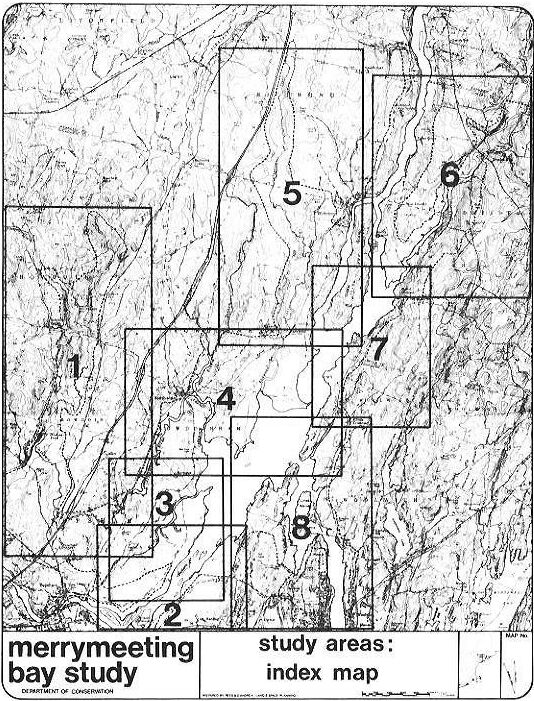
For ease of discussion, the land area around the Bay has been divided
into eight separate study areas, as indicated on the Index Map.
Actions are recommended then for each of these.
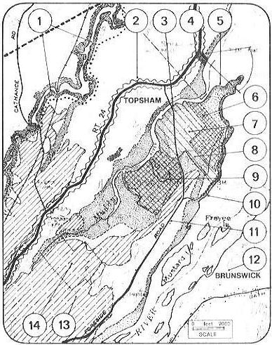
STUDY AREA 1 RECOMMENDATIONS
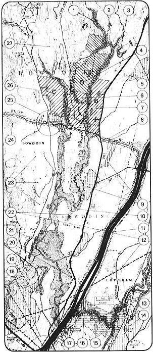
Most of the Cathance River drainage is included in this study area. It begins at the old mill site at the Cathance Road bridge in Topsham and extends west and then north into Bowdoin almost to the town of Litchfield.
The recommendations that follow suggest that much of the Cathance valley be protected and held out of development; in the upper valley around Bowdoin Center acquisition of some of this land for camping, picnicking, and trail sports is advocated; the broad flat marshlands in the vicinity of Bradley Pond should likewise be protected and kept for open space uses; finally the Cathance Gorge area between I-95 and the old mill is envisaged as a canoe and trail outdoor recreation area.
|
STATE ACTION |
DEPT |
MAP REF. NO. |
|
Trail system; possible extension of series of hiking,horseback riding, and winter sports trails associated with property acquisition program in areas shown cross-hatched (A,B,C,&D). |
D.O.C. |
2 |
|
Single large ownership parcel (+/-630 acres) contains varied topography and reverting fields. Consider acquiring for long term expansion of camping and outdoor recreation area to south (A&B). |
D.O.C. |
4 |
|
Acquire both areas for regional campground and recreation. (Area A between the two branches of the Cathance consists of 5 lots; Area B between Route 201 and the east branch of the Cathance comprises 3 lots). Both areas have excellent access, varied topography and some fine woodlands and are well suited to camping, hiking, etc., area equals 670 acres. |
D.O.C. |
6, 7 |
|
Power transmission lines (shown as broad dashed line). Find means to ensure that future power lines are kept in existing "corridors" so as to avoid visual chaos. |
P.U.C. |
12 |
|
Seek easements from property owners along east bank of the Cathance to establish state maintained hiking/horseback riding/nature trail that complements trails in the Cathance Gorge area. |
D.O.C. |
13 |
|
Acquire easements (possibly in conjunction with the town of Topsham) for eight parcels (shown with horizontal lines) on either side of the Cathance as area for canoeing, nature trails, hiking and horseback riding. Access is from Cathance Road at railroad tracks and possibly via the Radio Tower access road. Area equals 700 to 800 acres. |
D.O.C. |
15 |
|
Additional possible easements to enlarge and complete natural area mentioned above (5 more lots), |
D.O.C. |
16 |
|
Area "C" has third priority for acquisition as outdoor camping area to meet needs of region. Requires purchase of 4 parcels (total of +/-330 acres). Includes highland, marsh, steep slopes, and hiking areas along stream. |
D.O.C. |
26 |
|
TOWN of BOWDOIN |
MAP REF. NO. |
|
Zone entire length of stream Resource Protection (no structures within 250 feet of stream bank) to protect wildlife, reduce erosion and avoid flood dangers. Encourage owners to donate conservation easements to town. |
1 |
|
Require that all steep (+25P,) slopes be zoned Resource Protection or allow construction only on large (+10 acre) lots through a permit procedure that ensures adequate erosion control measures are taken. |
3 |
|
Aquifer recharge area; zone for low density (1 dwelling unit/2 acres) and ensure a minimum of impervious surfaces. Avoid contamination of soils from dumping or other unsanitary practices. |
5 |
|
Establish standards to ensure that Route 125 retains its rural/scenic character (setbacks, sign control, landscaping standards, etc.) as this route will be the main approach to camp and picnic area. |
8 |
|
Aquifer recharge areas--see reference "5" above. |
9 |
|
Zone as Resource Protection all those areas subject to flooding, erosion due to steep slopes or that have potential as waterfowl habitat. In many cases, this requires that the district be wider than the minimum 250 feet. |
10 |
|
Prohibit construction within 250 feet of I-95 by zoning Resource Protection so as to maintain rural view-from-the-road . |
11 |
|
Retain as marsh land; define extent and keep out of
development by zoning Resource Protection. |
22 |
|
Seek to establish large lot zoning in all rural locations within the town (min. lot size 5 acres). Permit up to 2 acres per dwelling unit where developer meets quality standards established by town (for example, if developer builds road to serve new lots, establishes common land, guarantees snow removal and/or in other ways helps reduce the town service costs). |
23 |
|
Prevent construction or pollution of marsh by defining extent of area of poor soil and zoning resource protection. |
24 |
|
Consider permitting one acre/unit density of area around Bowdoin Center except in those areas shown as aquifer recharge locations (vertical hatching). |
25 |
|
Rural areas, zone as suggested in reference "23" above. |
27 |
|
TOWN of TOPSHAM |
MAP REF. NO. |
|
Large aquifer recharge area (shown by vertical lines). Zone to minimize impervious ground cover (paved parking lots, large roofs, etc.). Permit maximum of 8% coverage or 2 acre/unit density for residential uses. |
14 |
|
Zone entire length of Cathance in Topsham Resource Protection--no structures permitted--so as to conserve and protect the river and its environs. |
17 |
|
Investigate rezoning I-95 intersection area for higher density residential, commercial and/or industrial uses. Establish means to ensure high quality development through standards and site plan review procedures. |
18 |
|
Aquifer recharge area avoid more than 8% impervious coverage. (for residences this equals a 2-acre/unit density). Zone 250-foot buffer along I-95 as Resource Protection to ensure pleasant view-from-the-road (with possible exception of intersection area). |
19 |
|
Entire dotted area to be designated Resource Protection because of its value as a wildlife habitat and its susceptibility to flooding. (Acquisition to permit an impoundment would necessitate purchase of over 30 properties, reconstruction of some roads, protection of power line supports, etc.). |
21 |
The recommendations that follow are for the lower Androscoggin
islands, its shoreline, and the shoreline properties, most of which
obtain access from the Foreside Road and the Old Bath Road. shores
are presently minimally protected by Topsham's and Brunswick's
Shoreland Zoning districts, however, both allow single and
multi-family residences (through a permit procedure) and in Brunswick
other uses may also be permitted.
Generally, the recommendations seek to protect the environmental and
scenic character of the area through a strengthening of existing town
zoning. actions recommended are listed below.
|
STATE ACTION |
DEPT |
MAP REF. NO. |
|
Develop old town bridge road as public boating access point. Provide landscaping and parking. Consider measures to restore floodplain and remove gravel storage from this area. |
D.O.C. |
12 |
|
Route 1 divided highway. Provide broad landscaped buffer on either side so as to preserve scenic view-from-the-road on this important tourist route. |
D.O.T. |
15 |
|
Encourage easements which act to conserve the Bay's character along all shoreline areas. Adopt policies which foster and encourage easements to be granted by private interests and help develop a management plan for maintaining the easements. |
D.O.C. S.P.O. |
all shorelines |
|
TOWN of TOPSHAM |
MAP REF. NO. |
|
Designate Routes 24 and Foreside Road as scenic through routes. Require deep setbacks on all building lots, minimize driveways exiting onto these routes. Set landscaping standards and sign control measures. |
1 |
|
Zone all areas subject to flooding within shoreland zone (shown as broadly spaced dots). Zone all areas which flood or have steep slopes and/or are in need of protection as Resource Protection (shown dotted) and prohibit all development. Encourage for agricultural use. |
2 |
|
Topsham municipal and ownership (cut by power lines) consider as park/recreational area; maintain in natural condition and improve as possible area for nature trails. |
3 |
|
Aquifer recharge area (shown hatched). Define and zone as low density (2 acres per unit minimun) so as to ensure a minimum of impervious: surface coverage. |
4 |
|
Muddy River basin, see study area 3 for recommendations. |
5 |
|
Coordinate all subdivision activity on small (5 to 15 acre) lots in this area. n row form of the lots and existence of flood conditions necessitate strict control. |
6 |
|
Zone all river islands as Resource Protection because of need to protect waterfowl habitat, avoid flood dangers, and conserve them as scenic assets, |
7 |
|
Mass of small narrow lots destroy integrity of shoreline. Avoid further subdivision and danger of septic tank pollution of the Bay especially to the area immediately southwest of these lots. |
8 |
|
Extent of suburban development on fringe of Topsham. Institute controls to limit density (because of recharge needs) and seek means to guide subsequent subdivision to ensure needed open space and logical pattern of streets and services. |
16 |
|
TOWN of BRUNSWICK |
MAP REF. NO. |
|
Zone all river islands as Resource Protection because of need to protect waterfowl habitat, avoid flood dangers, and conserve them as scenic assets. |
7 |
|
Expand shoreland zone to include entire area as Resource Protection as it fronts prime hunting area and is subject to flooding. Shoreline to northeast to be similarly zoned because of steep slopes. |
9 |
|
Ensure that land parcels adjacent to tidal flats and Resource Protection area are not developed. |
10 |
|
Existing mobile home park and new extension. Prevent further high density development of this nature through zoning change because of need for aquifer recharge (see note 13 below), |
11 |
|
Aquifer recharge area (shown hatched). Keep all development at low (2 acres per unit) density to ensure maximum absorptive surface area. |
13 |
|
Zone shoreland to ensure no structures in floodplain. Discourage profusion of driveways along Old Bath Road by building secondary collector streets. |
14 |
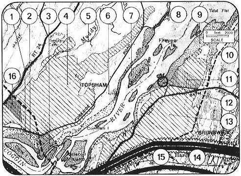
STUDY AREA 3 RECOMMENDATIONS
This study area focuses on the Muddy River watershed in Topsham.
Much of this area is marshland lying between Route 24 and the
Foreside Road; it includes two large state-owned parcels and land
owned by Topsham and used for a dump.
Presently Topsham's zoning does little to recognize the need for
protecting much of the Muddy River marshes. The recommendations that
follow suggest a variety of means for accomplishing this.
|
STATE ACTION |
DEPT |
MAP REF. NO. |
|
Proposed new public access site. Develop to create picturesque, landscaped site; design to discourage pleasure boaters but to suit hunters, fishermen, and smelt camp people, |
D,O,C, |
3 |
|
Consider acquisition of small parcel between Route 24 and the Bay as scenic turnout and picnic site. (This could be in addition to or in place of the location suggested in Study Area 4, reference 18.) |
D.O.T. |
4 |
|
State owned demonstration forest; no specific recommendations. |
D.O.C. |
6 |
|
Possible expansion of state owned Muddy River properties. Acquisition of 5 or 6 parcels would give state a large (+500 acres) contiguous area on the river for wildlife management. Good, class I soils would permit leaseback to farmers and allow cultivation of goose feed. |
D,O,C, |
7 |
|
Recently acquired parcel is wholly within floodplain. Is excellent wildlife habitat and could be enlarged (see reference 7). |
I,F,&G, |
9 |
|
Encourage easements which act to conserve the Bay's character along all shoreline areas. Adopt policies which foster and encourage easements to be granted by private interests and help develop a management plan for maintaining the easements. |
D.O.C. |
all shorelines |
STUDY AREA 4 RECOMMENDATIONS
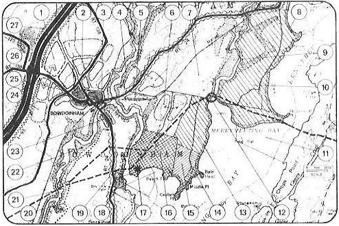
This area comprises the village of Bowdoinham, the lower Cathance and Abagadasset, and much of the lowland frontage on the Bay.
The following is a listing of recommendations relating to the conservation and protection of the area's environmental attributes. The most important recommendations concern the zoning of flood prone areas for agricultural use only, the expansion of the Game Management Area and the development of a Merrymeeting Bay nature/visitors center.
|
STATE ACTION |
DEPT |
MAP REF. NO. |
|
Suggest S.D.O. assist town in developing these sites as highway-related commercial/industrial because of their importance regionally and relative to I-95 as transportation corridor. |
S.D.O. |
1 |
|
Public access area to be landscaped. |
D.O.C. |
3 |
|
Consider as potential industrial (non-polluting) site with good soils, slopes, and rail-siding access. |
S.D.O. |
5 |
|
Consider forms of land management of large forested parcels with Class I & II soils on east of Abagadasset. Clear these lands for goose feed planting with view toward turning the lands back to productive farmland at a future time through an agreement with local farmers in order to recover capital costs. |
D.Agric. IF&G |
10 |
|
Waterfowl sanctuary--not in need of extension. |
I,F,&G, |
11 |
|
Abby bridge access point. Develop as public access for duck hunters, canoeists, and fishermen. Provide adequate parking area. |
D.O.C. |
12 |
|
Small lots (less than 30 acres) fronting on Bay; consider for easements if land to west purchased (by state). Area is liable to floods, contains swamp land and generally unsuited to development. Eagles nest on Bald Head. |
D.O.C. |
14 |
|
Extend state ownership of Game Management Area through acquisition of single large parcel. Includes large area in need of protection and scenic promontory at Centers Point. |
D.O.C. |
15 |
|
Existing Game Management Area. |
D.O.C. |
16 |
|
Develop as Merrymeeting Bay nature/visitors/education center with overlook to tidal flats, exhibit area, and nature conservation trails that illustrate the ecology of the Bay. |
D.O.C. |
17 |
|
Purchase of highway scenic overlook and picnic area. Most northerly parcel has first priority. |
D.O.T. |
18 |
|
Seek easements from property owners along Cathance for state-maintained trail systems (hiking and horseback riding in season) that link with similar trails in Topsham. |
D.O.C. |
20 |
|
Central Maine Power high voltage power lines. Have P.U.C. require that Central Maine Power keep future lines (if any) in existing corridors rather than establish new ones. |
P.U.C. |
21 |
|
Buffer along length of I-95 to reduce noise pollution and add visual protection. Consider strategic landscaping and building setback requirement. |
D.O.T. |
27 |
|
Encourage easements which act to conserve the Bay's character along all shoreline areas. Adopt policies which foster and encourage easements to be granted by private interest and help develop a management plan for maintaining the easements. |
D.O.C. S.P.O. |
all shorelines |
|
TOWN OF BOWDOINHAM |
MAP REF. NO. |
|
Zone or acquire (through town CDC) as highway-related commercial/industrial area. Extend town's planned sewer system to serve and enlist S.D.O. help. |
1 |
|
Designate as medium density residential development (1/2 acre density) served by town sewers and water. Plan as coherent whole through site plan review, imposed hierarchy of streets, and use of incentives. Build new neighborhood-scaled streets off through routes. Consider acquisition of areas, and selling to developers interested in building in the town; or swapping for areas proposed for development outside this zone. |
2 |
|
Entire West Branch zoned as Resource Protection (shoreland district) with no structures because of value as waterfowl breeding habitat, small watershed (erosion dangers) & steep (+25%) slopes in north. Large dot at north end of West Branch is existing town dump. This site should be restored and a new dump located on the White Road as a combined facility for Bowdoinham and Richmond residents. |
4 |
|
Potential industrial (non-polluting) site with good soils, slopes, and rail siding access. Zone to allow light, non-polluting industry in the area indicated. |
5 |
|
Designate as low density (l-acre lot minimum) residential area near village. Establish setbacks from through routes and develop as discrete "clusters." |
6 |
|
Zone as rural residential areas (5-acre minimum lot size) all those areas not designated otherwise on this map and which have poor soils, poor access to village and abut rural roads. Discourage development in these areas so as to ensure preservation of rural countryside. Seek conservation easements from landowners. Permit 2-acre density if cluster concept used. |
7 |
|
Zone all shoreland adjacent to tidal flats Resource Protection as buffer to waterfowl feeding areas and erosion control. |
8 |
|
Zone as Resource Protection on basis of waterfowl and rare fishery habitat (sturgeon), smelt fishery, and canoeing needs. Area is also subject to flooding. |
9 |
|
Zone entire area between Abagadasset and Bay as Agricultural Zone (or as Floodplain) because of Class I agricultural soils and flood danger. |
10 |
|
Zone as agricultural zone (cross-hatched area) to ensure conservation of valued soils (or as floodplain). See Ref. above. |
13 |
|
Designate Route 24 as scenic highway and establish standards to ensure adequate landscaping, scenic view-from-the-road sequences, setbacks for construction, and distances between driveways in order to maintain rural character and increase highway safety. |
19 |
|
Zone as Resource Protection (no structures) because of marsh, smelt fishing, flood danger, and steep slopes. Lower Cathance is also good canoe stream. |
22 |
|
Limit extension of sewer service to discourage growth along scenic Route 24. |
23 |
|
Extension of village residential area (long term) 1-acre density if no sewer; 1/2-acre density if sewer service made available. Coordinate planning and utilize incentives to achieve community-wide open space objectives. Build suburban streets off Route 138. |
24 |
|
Hatched area indicates existing village, built-up area. Permit mix of land uses to maintain small town character. |
25 |
|
Low-lying area west of I-95; keep out of development. Acts as good "front door" to access road to upper Cathance camping/recreational area. |
26 |
STUDY AREA 5 RECOMMENDATIONS
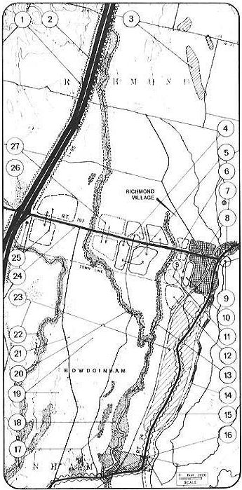
The Abagadasset watershed is central to this study area which also takes in part of I-95, Richmond Village, and the northeast section of the town of Bowdoinham.
The recommendations listed below deal primarily with the village of Richmond and its immediate surrounds, and with a concern for protecting stream edges in Bowdoinham. The map/diagram emphasizes the need for continuity in land use regulation between these two towns, one of which (Richmond) has zoning legislation; the other (Bowdoinham) being in the process of writing such legislation.
|
STATE ACTION |
DEPT |
MAP REF. NO. |
|
Landscape highway edges to beautify and cut down on noise pollution |
D.O.T. |
1 |
|
Existing boat landing. No action required; maintain as scenic, landscaped area. |
D.O.C. |
9 |
|
Excellent view from Route 24 toward the Bay and Swan Island Point. Consider easement program by DOT & DOC of two properties on either side of road (shown hatched) for scenic viewing area. Western property fronts on Abagadasset and is good access point (see Study Area 4, ref. 12). |
D.O.C. D.O.T. |
16 |
|
Consider combined farm assistance/goose management program whereby farmland is either leased by the Department of Inland Fish & Game and planted for goose feed or purchased for goose management during the "flyover" season and leased back to farmers for the remainder of the year. |
IF&G D.Agric. |
23 |
|
Consider assisting Richmond with the development of these commercial/industrial sites. |
S.D.O. |
25 |
|
Encourage easements which act to conserve the Bay's character along all shoreline areas. Adopt policies which foster and encourage easements to be granted by private interest and help develop a management plan for maintaining the easements |
D.O.C. S.P.O. |
all shorelines |
|
TOWN of RICHMOND |
MAP REF. NO. |
|
Zone entire Abagadasset Resource Protection (no structures within 250 feet of the stream bank). Currently residential structures are permitted through a permit procedure. Flooding, soil conditions, the value of this area for wildlife argue for this designation as does the need to avoid erosion in this relatively small watershed. |
2 |
|
Hatched areas shown are aquifer recharge locations. Steps should be taken to insure the pervious ground surface is not endangered by excessive coverage or pollutants. |
3 |
|
Review existing zoning to permit neighborhood-type commercial activities to locate in this area(laundromat, gas station, general store, etc.) but only if access is strictly controlled to minimize traffic complications. |
4 |
|
Encourage future residential construction in this area, close to, but west of the village by constructing road and sewer service to these areas only. Use incentives to accomplish this and to avoid further new construction fronting on Route 197. Arrows indicate preferred access point. |
5 |
|
Possible expansion of Eaton Shoe-type facility to the north side of Route 197, to create small "in-town" industrial park. Landscape both sides of road to screen car parking and improve visual entry into village. |
6 |
|
Study the feasibility of relocating the town dump as it is poorly located and a potential (if not actual) polluter. It is also subject to flash flood wash out danger. Ifork with Bowdoinham to establish a cooperative dump. |
7 |
|
Existing village area shown cross hatched. Zone as historic district with special building controls so as to preserve Richmond's rich architectural character. |
8 |
|
Expand residential growth in this direction and construct new roadway to link Route 197 and Route 24 to the south. This road would reduce traffic through the village center and act as a buffer between the village and new development to the west. |
10 |
|
Existing new school. Suggest town acquires and plans this general area for recreational, civic, and educational programs and facilities and bicycle trails and paths from major residential concentrations to schools but separate them from vehicular traffic. |
11 |
|
Route 197. Work with D.O.T. to upgrade and maintain as important through route. Require sign controls, adequate setbacks, provision for possible street widening, means to limit the number of driveways exiting onto the road and any other measures necessary to increase safety and improve the visual quality of the route 8-46 |
24 |
|
Potential industrial/commercial sites on either side of Route 197 at I-95 intersection. Both have high visibility, excellent access and sewer and water service can be extended from the village. Soil conditions good. Consider zoning "*" site for a commercial use requiring the good highway visibility this site provides (motel, gas station, research and development office, etc.). |
25 |
|
Marsh, zoned Resource Protection at present, but limits value of land adjacent which is zoned for commercial/industrial uses. Suggest assigning priority to areas designated by map reference 25. |
26 |
|
Second phase of expansion of village residential area. Use sewer and water service and public underwriting of new road construction (located near arrows) as incentives to guide development into this area without increasing the number of driveways fronting on Route 197. Undertake site plan review (by Planning Board) to ensure a good plan featuring needed neighborhood facilities. |
27 |
|
TOWN of BOWDOINHAM |
MAP REF. NO. |
|
Zone 250-foot strip alongside I-95 as Resource Protection so as to avoid excessive noise nuisance and to create a scenic view from I-95. (Richmond has already zoned its land along the highway into this district.) |
1 |
|
Potential industrial site utilizing rail access and proximity to I-95. Site is flat, could connect to Richmond's water and sewer service; non-polluting industry here could possibly strengthen Bowdoinham's tax base and offer employment to local residents. |
12 |
|
Designate area shown dotted as Resource Protection under Shoreland Zoning Ordinance. Area includes 250 feet on either side of stream plus those areas susceptible to flooding, erosion (because of steep slopes) or useful as waterfowl habitat. Matches Richmond zone. |
13 |
|
250-foot wide strip of shoreland fronting on the Kennebec to be zoned Resource Protection (where dots are clustered) and in those areas subject to flooding (not necessarily 250 feet wide). Remainder to be residential, through permit procedure, and with combined lot plus setback total equal to 500 feet or more (see Richmond's Shoreland Zone). Septic setbacks should be set at 250 to 300 feet. |
14 |
|
Consider designation of Route 24 as scenic highway in order to conserve its rural character. Establish standards to ensure good landscaping, sign controls, building setbacks and limitations on the distance between driveways exiting onto the road. |
15 |
|
Steep (+25%) slopes; zone as Resource Protection or permit construction only on large lots (10+ acres) through permit procedure to ensure that adequate erosion control measures are taken. |
17 |
|
Zone as Resource Protection. Broaden zone to include all flood-prone areas. Poor soils and suitability of area for smelt fishing, waterfowl habitat, and canoeing also argue for retaining this location in its natural state, as does its inaccessibility. |
18 |
|
Maintain character of this general area by perpetuating large parcel ownership that exists. Zone as rural, low density district (min. lot size 5 acres) to ensure protection of valued farm and forest land; allow 2-acre density if cluster concept is used. |
19 |
|
Zone Abagadasset River Resource Protection to ensure erosion is controlled in this small watershed, to protect wildlife, and to avoid stream pollution. |
20 |
|
Consider locating new dump for Richmond and Bowdoinahm on the White Road equidistant from the two village centers. Consult with Department of Environmental Protection and Bureau of Geology as to best location. |
21 |
|
Define marsh/bog area and zone to prevent construction therein. Likewise zone shoreline of Denham Stream Resource Protection so as to control erosion, prevent pollution, and sustain wildlife. |
22 |
STUDY AREA 6 RECOMMENDATIONS
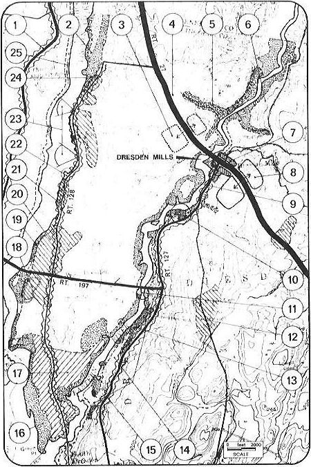
Study Area 6 focuses on the Kennebec and Eastern River valleys in the town of Dresden. Since the town has no zoning ordinance, many of the recommendations could be used to help establish land use controls; other points listed below deal with a broadening of the shoreland Resource Protection Zone, the establishment of an Agricultural District, and the definition of scenic routes. The extensive Resource Protection District advocated for the eastern shoreline is called for because the drainage area is small and the need to prevent erosion that could harm fish and bird life is great.
|
STATE ACTION |
DEPT |
MAP REF. NO. |
|
New boat access area recently acquired by state. Avoid structures in floodplain; design to provide for canoeists, fishermen, and waterfowl hunters, and to discourage recreational motorboating; consider for use as scenic picnic area; landscape and provide well-planned boat and vehicular parking area. |
D.O.C. |
10 |
|
Consider acquisition of development rights for valuable agricultural lands in Green Point Area in lieu of town action to zone for agriculture. |
D.Agric. |
17 |
|
State-owned gravel pits. Reclaim unused portions through landscaping. Establish overall reclamation schedule to ensure useful "afterlife." |
D.O.T. |
18 |
|
Views from the road--probably not worthy of acquisition, especially in light of possible nuclear site across river. |
D.O.T. |
23 |
|
Encourage easements which act to conserve the Bay's character along all shoreline areas. Adopt policies which foster and encourage easements to be granted by private interest and help develop a management plan for maintaining the easements. |
D.O.C. S.P.O. |
all shorelines |
TOWN of DRESDEN
Include entire area (shown dotted) as Resource Protection under Shoreland Zoning because of its value as a natural resource and the fact that it is within the floodplain. Permit agricultural uses on prime soils (lightly dotted).
|
TOWN of DRESDEN |
MAP REF. NO. |
|
Consider for long-term future residential use as planned subdivision (1 acre/unit density). Encourage development here through incentives since access, soils, and location are all favorable. Route 27 is important through way (over 2000 vehicles/day). Maintain as such by instituting setback, sign and driveway controls. |
3 |
|
Expand existing Shoreland Zoning to include areas shown dotted on either side of Eastern above Route 27. Flooding dangers and/or steep slopes and waterfowl habitat make protection necessary. |
5 |
|
Seek means to discourage further subdivision into long narrow lots between road and river by encouraging "cluster" concepts, common ownership of river frontage or easements and covenants. |
6 |
|
Existing village of Dresden Mills. Maintain as town center. Permit denser clustering of buildings, if sewered (1/2 acre or less); consider small town sewage plant. Maintain historic image through architectural and sign controls and minimize off-street parking and drive-ins. |
7 |
|
Logical expansion of village residential area as soils, access, topography, etc., make this area most suitable for subdivision activity--provided that Route 27 is kept as through route and no driveways exit to it. |
8 |
|
Expand existing Resource Protection District to cover entire flood-prone lowland on west bank of the Eastern River. |
9 |
|
Town-owned access point--improve for boat launching; landscape. |
11 |
|
Cross-hatched areas like this are aquifer recharge locations. Because underground water supplies are "charged" from these areas, impervious ground cover should be minimized. Insist on density of one unit per two acres minimum. |
12 |
|
Expand Resource Protection District to include steep (+25%) slopes. |
13 |
|
Zone for large lots or generous frontage/setback requirements (area between Route 127 and River as shown on map) because of need to protect scenic value and steep slopes from erosion. |
14 |
|
Designate Route 127 (between Dresden Mills and South Dresden) as scenic route. Maintain sign control, setbacks, clearings for views, etc. |
15 |
|
Redefine extent of Resource Protection District to take flooding danger into account. No structures should be permitted in this area, especially as it is in need of environmental protection. |
16 |
|
Designate Green Point area (shown cross-hatched) as Agricultural District so as to protect first and second class agricultural soils. Permit only agriculturally related uses in district. |
17 |
|
Designate Resource Protection those areas which are subject to flooding (dotted pattern). Shoreline without dotted pattern to be zoned for single family residential through permit procedure and with combined lot and setback, total to equal 500 feet or more. |
19 |
|
Aquifer recharge location; maintain low density (1 unit/2 acres) to ensure adequate pervious ground surface. |
20 |
|
State Route 128. Designate as scenic route where road parallels Kennebec. Maintain sign controls, landscape standards, and setback requirements. |
21 |
|
Court House Point and location of historic Pownalborough Court House. Seek assurances building and property will be adequately maintained and preserved by the private sector. Acquire if these assurances are not forthcoming (through town, private, and/or state funding). |
22 |
|
Aquifer recharge area (see note 20 above). |
24 |
|
TOWN of RICHMOND |
MAP REF. NO. |
|
Designate Route 24 in Richmond as a scenic rural through route. Require deep building setbakcs; limit distance between driveways; set landscaping and sign control standards. |
1 |
|
Kennebec shoreline is fairly well protected by existing shoreland district but no structures should be permitted in flood-prone areas or a plus 25% slope (shown dotted). |
25 |
STUDY AREA 7 RECOMMENDATIONS
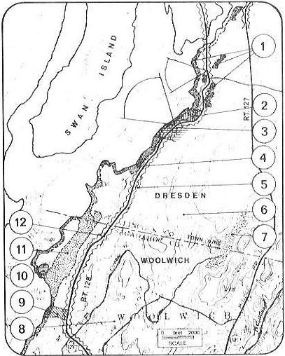
This study area lies partly within Dresden and Woolwich and consists principally of that area between Route 128 and the Bay shoreline. main recommendations relate to the upgrading of Route 128 as a scenic road and the protection of the shoreline.
|
STATE ACTION |
DEPT |
MAP REF. NO. |
|
Consider acquisition of single property on Cork Cove as new access point to the eastern part of the Bay; design exclusively for hunters, fishermen, and canoeists and avoid use by recreational motor boats. |
D.O.C. |
2 |
|
Purchase easement on Route 128 with shore frontage as scenic iookout; consider joint use (with D.O.C.) as picnic area. Combine ownership and management with adjacent property to north (see ref. 2, above). |
D.O.T. D.O.C. |
3 |
|
TOWN of DRESDEN |
MAP REF. NO. |
|
Broaden existingRsource Protection District to 250 feet or more where flooding occurs and/or where steep slopes (+25%) exist. |
1 |
|
Combination of flood-prone shoreline and steep slopes necessitates Resource Protection Distuict in this area in particular. |
4 |
|
Establish as scenic route (with assistance from D.O.T.); create standards to control signs, setbacks, landscaping, traffic safety, etc. |
5 |
|
Zone rural aceas away from villages and principal intersections as large lot residential/agricultural districts (min. density 5 acres/unit) unless the owner-developer institutes design and planning improvements that benefit the community; in such a case a higher density may be permitted (up to 2 acres/unit). |
6 |
|
Wetland; avoid any construction by defining extent of marsh and zoning Resource Protection. |
7 |
|
Zone rural areas for large lot development (min. density 5 acres/unit) unless design improvements that benefit the town are included; in such a case density bonus should be awarded comensurate with the extent of the improvement. In no case should the final density be less than 2 acres/unit. |
8 |
|
Robert Tristam Coffin Wildflower Preserve; consider expansion by acquisition of parcels to north and/or south. |
9 |
|
Aquifer recharge area; avoid construction in this area.that results in coverage of more than 8%. |
10 |
|
Large flood-prone area that also contains some prime agricultural soils; zone as Resource Protection yet permit farming practices. |
11 |
|
Designate with D.O.T. assistance as scenic route; establish standards to maintain scenic quality. |
12 |
STUDY AREA 8 RECOMMENDAT IONS
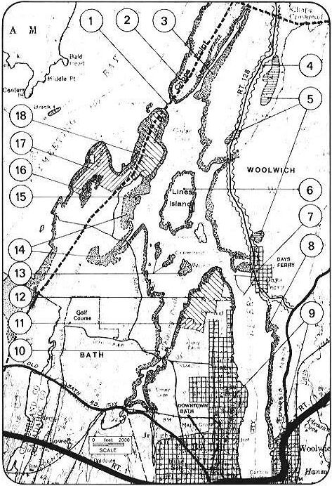
This study area contains portions of both Bath and Woolwich. It
centers on the Kennebec River from the Carlton Bridge clear to the
Chops and the Bay itself and includes Lines Island.
At present, very little of the shoreline is zoned Resource Protection
yet the scenic charal3ter of the area calls fo_ further measures to
protect this valuable visual resource. rfcommendations that follow
address these and other concerns.
|
STATE ACTION |
DEPT |
MAP REF. NO. |
|
Avoid placement of further power lines across this scenic area. y are visually obtrusive and reportedly kill birds of prey in flight. |
P.U.C. |
1 |
|
Consider acquisition of Lines Island as wildlife management area. |
IF&G |
6 |
|
Consider acquisition as part of wildlife management area mentioned above. |
IF&G |
13 |
|
Encourage easements which act to conserve the Bay's chauacter along all shoreline areas. Adopt policies which foster and encourage easements to be granted by private interest and help develop a management plan for maintaining the easements. |
D.O.C. S.P.O. |
all shorelines |
|
TOWN of WOOLWICH |
MAP REF. NO. |
|
Revise Shoreland Zoning to make the majority of the shoreline Resource Protection (no structures within 250 feet of the highwater line) so as to preserve scenic quality, minimize erosion, and avoid flooding hazards. Zone Chops Point for large lots (1 unit per 10 acres) because of poor access, steep slopes, and the need to conserve this picturesque and significant natural area. |
2 |
|
Chops Creek; extend existing zoning (which is Resource Protection) to include all flood-prone areas and all slopes of +25%. |
3 |
|
Seek, through assistance from the Dept. of Transportation means to uygrade Route 128 as a scenic through route. Set standards to ensure sign control, adequate building setbacks, safe driving conditions through driveway permit review; etc. Zone rural areas alongside this route low density (minimum lot size 5 acres) unless improved design warrants "bonus" of higher density. |
4 |
|
Aquifer recharge areas; avoid residential density of less than two acres per unit so as to ensure low coverage and a minimum of impervious surfaces. |
5 |
|
Zone Lines Island shore Resource Protection. Seek means to purchase Island (with Bath and/or state) so as to conserve as wildlife and natural area. Review current plans for subdivision and resolve jurisdictional questions with Bath. |
6 |
|
ay's Ferry area; retain unique village-architectura1 character by zoning as Historic District with strict architectural and sign controls; keep views to water open and consider (with D.O.T.) provision of scenic turnout. |
7 |
|
Zone as Resource Protection District so that no structures are in flood-prone areas, erosion is minimized, and septic tank systems are not constructed near to the shoreline. |
8 |
|
The built-up area of Woolwich is shown cross-hatched. |
9 |
|
TOWN of BATH |
MAP REF. NO. |
|
Zone Lines Island shoreline Resource Protection. Seek means to acquire with Woolwich(and/or state) as wildlife management areas. Review current subdivision plans and consider their outright rejection. Resolve jurisdiction with Woolwich. |
6 |
|
Built-up (urban) area shown cuoss-hatched. |
9 |
|
Zone all shoreline outside urban areas Resource Protection or (as compromise) permit single-family structures provided frontage plus setback equals a minimum of 500 feet and septic tanks are setbaik 250 feet. |
10 |
|
Site of town dump; retain dump on inland portion of site (or seek combined Bath/Brunswick dump site convenient to both towns) and develop remainder (or all) of site for outdoor recreaion. |
11 |
|
Acquire two parcels north of City Dump (Thorne Head) as natural preserve; acquisition of these parcels for futuue use of Bath citizens wilt assure this attractive area is kept out of development and not despoiled. |
12 |
|
Zone each entire island Resource Protection--no structures permitted. (If not acquired by state, consider city or joint city/state acquisition). |
13 |
|
Enlarge extent of current shoreline district to fit with location of flood-prone areas, marsh and poor soils (unsuitable for septic tanks). |
14 |
|
Avoid proliferation of small lots (as along Varney Mill Road) by zoning the area north of Whiskeag Road for large (+5 acre) lots. Permit higher density in exchange for positive design elements such as provision of common land, private sewers, development roads, etc. |
15 |
|
Zone steep (+25%) slopes Resource Protection or pennit construction only on large lots (10 acres) if strict erosion protection measures are followed. |
16 |
|
Existing city-owned land; undertake study to determine best use--ensure open space character is maintained. Zone shoreline owned by city Resource Protection.. Consider public hunter and fisherman access point (no pleasure craft permitted). |
17 |
|
Purchase 3 (or 4) parcels to obtain ownership of entire West Chops Point; combine with present ownership and determine best use for Bath citizens--give serious consideration to system of walking, horseback riding, and winter sports trails. In any event, zone all flood-prone lands and entire peninsula shoreline Resource Protection. |
18 |
8,3 : REFERENCES
Community Planning Services. 1970. Sewer and water. A report to the
Bath/Brunswick Regional Planning Commission, Bath, Maine. 25 p.
Economic Research Service. 1972. Rural'zoning in the United States:
analysis of enabling legislation. U. S. Supt. of Documents.,
Washington, D. C, 170 p.
Johnson, Craig. 1966. Practical operating procedures for progressive
rehabilitation of sand and gravel sites. NationalSand and Gravel
Association, Silver Springs, Maryland. 75 p.
Kline, Elizabeth. 1975. Protecting open space; a guide to selected
protection techniques. Society for the Protection of New Hampshire
Forests, Concord, New Hampshire 83 p.
Maine Department of Conservation, et al. 1973. regulation of outdoor
advertising in Maine; a model ordinance for towns. Department of
Conservation, Augusta. 7 p.
Maine Mining Commission, Keep Maine Scenic Commission, Natural
Resources Council of Maine, Associated General Contractors of Maine,
Maine Audubon Society, Soil and Water Conservation Commission, and
Maine State Highway Commission. 1972. A citizens guide to gravel pit
reclamation and beautification. Augusta, mimeo.
Maine State Planning Office. 1972. Planning board standards for
reviewing subdivisions. State Planning Office, Augusta.
Maine State Planning Office. June 1973. regulation of outdoor
advertising in Maine: A model ordinance for towns. State Planning
Office, Augusta.
Maine State Planning Office. Dec. 1973. Model zoning ordinance for
Maine communities. State Planning Office, Augusta.
Pennsylvania Land Policy Project. 1974. A land use strateW for
Pennsylvania, a fair chance for the faire land of William Penn.
Pennsylvania Office of State Planning and Development, Harrisburg.
209 p.
Redlich, Susan. 1974. Guiding growth, a handbook for New Hampshire
townspeople. Society for the Protection of New Hampshire Forests,
Concord, New Hampshire. 117 p. and app.