
|
|

|
|
|
|
|
Executive Summary
This report provides information about fish and wildlife resources and conservation lands in theMerrymeeting Bay and Lower Kennebec River of coastal Maine, and identifies strategies and opportunities to protect high value habitats. Our analysis identified 10,920 ha (27,000 acres) of high value habitats as candidates for possible protection under the North American Waterfowl Management Plan. Strategies and opportunities to protect these habitats are described and are based on cooperative partnerships between landowners and conservation agencies. Such strategies include conservation easements, land acquisition, agricultural incentives, conservation education, state and local environmental regulations, and zoning.
Introduction
The North American Waterfowl Management Plan (NAWMP) was approved by Canada and the United States in 1986. The Plan has provided the impetus for protection and enhancement of wetland and adjacent upland habitats critical to North American waterfowl by establishing population goals for ducks, geese, and swans, and by designating priority habitat areas within which protection efforts would be most effective. The Atlantic coast was identified as one of these areas.
The Plan recommended the establishment of "joint ventures" among federal and state governments, conservation organizations, local groups, and private citizens in order to combine resources and coordinate planning, funding, and implementation of projects to protect habitats in the priority areas.
The Maine Wetlands Protection Coalition (MWPC) was organized to support NAWMP's Atlantic Coast Joint Venture by developing habitat protection strategies throughout the state of Maine. Major governmental cooperators in the Merrymeeting Bay and Lower Kennebec River habitat protection effort are the U.S. Fish and Wildlife Service (USFWS), the Maine Department of Inland Fisheries an þd Wildlife (MDIFW), and the Maine Department of Agriculture. Efforts of the Brunswick-Topsham Land Trust, the Lower Kennebec Regional Land Trust, the Phippsburg Land Trust, and the Friends of Merrymeeting Bay are also essential to the planning process. Other participating conservation organizations include The Nature Conservancy, Maine Coast Heritage Trust, and Ducks Unlimited, Inc.
The MWPC established the Merrymeeting Bay and Lower Kennebec River as one of five Focus Areas in Maine for the Atlantic Coast Joint Venture. Focus Areas are defined by NAWMP as wetlands and associated upland habitats within the joint venture area that are high priority wintering, migration, or production habitats for black ducks and other waterfowl.
The Merrymeeting Bay and Lower Kennebec River Focus Area is located approximately 48 kilometers (30 miles) northeast of Portland, Maine. Merrymeeting Bay is one of the largest and most important freshwater tidal ecosystems in the United States. It lies at the confluence of two major rivers and four smaller tributaries, creating a biologically rich and diverse area. The Lower Kennebec River is the outlet of Merrymeeting Bay and is an estuarine area consisting of extensive salt marsh and mud flat habitats. The Lower Kennebec River empties into the Gulf of Maine.
The Focus Area contains habitat of primary importance during spring and fall waterfowl migrations and has been recognized traditionally as one of the premier areas for waterfowl hunting on the Atlantic coast. It is ecologically diverse, with more than a dozen federally and state-listed threatened or endangered species found there. Osprey and bald eagles nest along the shores. Extensive freshwater marshes fringing the bay provide wild rice and other plant foods for waterfowl, and also support a number of rare plants. Large tracts of farmland, open land, forests, salt marshes, and mudflats provide additional feeding and nesting areas for migratory birds.
Purpose of Study
The intent of our analysis was to identify highest value habitats in the Focus Area for possible protection under the Atlantic Coast Joint Venture of the North American Waterfowl Management Plan. The report also identifies cooperative initiatives and opportunities for implementing land protection strategies in these areas. Specifically, the report identifies and maps the following:
Using a geographic information system (GIS), we mapped the fish and wildlife resources of the Focus Area using state, private, and federal natural resource databases. By overlaying the most important resources identified in the NAWMP, we identified and delineated the habitats of highest value in the Merrymeeting Bay and Lower Kennebec River Focus Area.
This delineates the Merrymeeting Bay and Lower Kennebec River Focus Area in relation to geographic and political features. Superimposed are outlines of the 7.5 minute topographic quads (solid grid) and the town boundaries (fine black dashed lines). Roads (red), streams (blue), and town names, as well as water and land surfaces, help situate the observer to the areas of concern. Most of these layers were obtained through the Maine Office of GIS from U.S. Geological Survey (USGS) data.
The following figures indicate the diversity of organisms and wetland types characteristic of the Focus Area.
Breeding Bird Atlas (Figure 2a)
The number of bird species for which indications of breeding were observed is shown for each USGS 7.5 minute quad of the focus area. Because the data are accumulated from inputs by a number of volunteers rather than a survey with consistent level of effort, the interpretation must be regarded with caution. This also applies to the herpetological data (below). The database was obtained from MDIFW (original source: Adamus, P.R. 1988. Atlas of Breeding Birds of Maine, 1978-1983. MDIFW, Augusta. 366pp.).
Amphibians and Reptiles (Figure 2b)
This map shows the number of species recorded for each town within the focus area. These data were obtained from MDIFW (original source: Hunter, M.L., J. Albright, and J. Arbuckle, eds. 1992. The Amphibians and Reptiles of Maine. Maine Agricultural Experiment Station Bulletin 838. 188pp.).
This figure displays open water habitat which corresponds to the upstream migratory pathways mapped for any of the nine anadromous fish species using the project area (Eipper, A., W. Knapp, and C. Laffin. 1982. Anadromous Fish Streams of New England: Upstream Migratory Routes. Portfolio NE-1. USFWS).
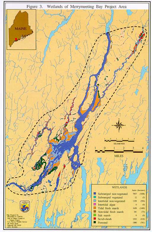
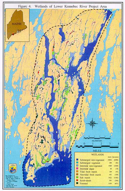
Wetlands of the Merrymeeting Bay Project Area (Figure 3)
Wetlands of the Lower Kennebec River Project Area (Figure 4)
Wetlands within the focus area are of critical interest because of their habitat value and productivity for coastal ecosystems. The Fish and Wildlife Service's National Wetland Inventory (NWI) mapped and characterized wetlands for the area of interest in 1992, using 1985 aerial photography. NWI classifies wetlands according to a multitiered scheme; major systems are lacustrine, riverine, palustrine, estuarine, and marine. Under these are subsystems (e.g., intertidal, subtidal, limnetic, lotic, etc.) then several levels based on substrate or vegetational characteristics and physical or chemical modifiers. We digitized the NWI wetland polygons with their original wetland coding and then renamed and grouped them into nine classes or "cover types" that are particularly relevant from the perspective of waterfowl habitat. These plots for the Merrymeeting Bay and Lower Kennebec River project areas display wetlands and list total area for each of the classes; not all classes occur in each area.
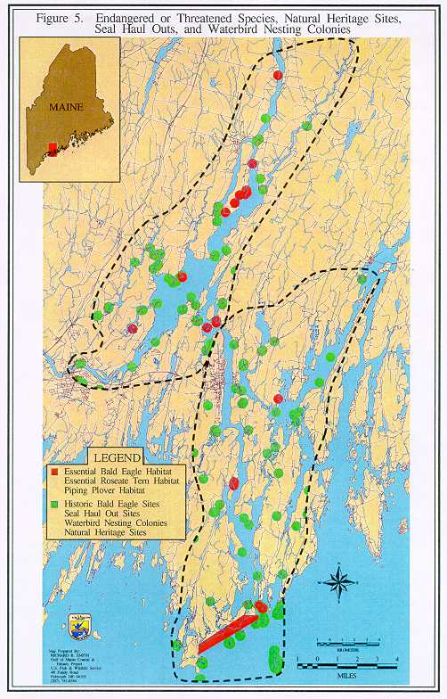
This map depicts: bald eagle and roseate tern essential habitats and historic bald eagle nest sites (MDIFW); piping plover habitats (USFWS); Natural Heritage Program sites (rare, threatened, and endangered species and communities); seal haul outs (University of Maine Wildlife Department and MDIFW); and waterbird nesting colonies (MDIFW and USFWS). A 402 meter (1320') radius buffer zone was calculated and mapped for each of the species. Essential bald eagle, essential roseate tern, and piping plover habitats are plotted in red while historic eagle nests, Heritage sites, seal haul outs, and waterbird sites are shown in green.
The purpose of our analysis was to identify the highest value waterfowl habitats, associated buffer zones, and threatened and endangered species habitat within the Focus Area. These habitats are prime candidates for protection under the Atlantic Coast Joint Venture of the North American Waterfowl Management Plan.
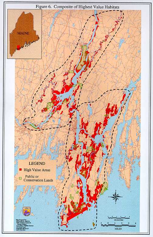
Composite of Highest Value Habitats (Figure 6)
Wetlands and threatened and endangered species are particularly relevant to the goals of the North American Waterfowl Management Plan. These were used as the basis for identifying the priority localities. In a series of GIS operations we 1) assigned ratings to the wetlands as waterfowl habitat, 2) selected the highest and intermediate value habitats, 3) identified buffer zones adjacent to such wetlands, 4) mapped habitats of threatened or endangered species, and 5) combined the waterfowl and threatened or endangered species information to create a single map composite.
Values of waterfowl habitat were interpreted from the NWI coverages described above, based on relative utilization of those wetland types by black ducks and eiders. Waterfowl locations and seasonal counts were obtained from an unpublished MDIFW study (Marine Wildlife Inventory of Sheepscot Bay, Maine; March 1983). We rated the wetland types according to relative numbers of birds observed within them. The following classes were given the highest waterfowl rating: intertidal non-vegetated, tidal fresh marsh, intertidal algae, and salt marsh. Submerged non-vegetated, submerged vegetated, and non-tidal fresh marshes were assigned an intermediate score. Scrub-shrub and forested wetlands were given a lower rating.
Uplands adjacent to these waterfowl habitats are of particular interest for purposes of the North American Waterfowl Management Plan. Their protection could limit unsuitable development activities and allow beneficial habitat management. To highlight these adjacent lands we created a 90 meter (295') buffer zone around the waterfowl habitat and assigned them the same value as the associated wetland.
The other theme we used for determining highest value habitats was the occurrence of federal threatened and endangered species; this theme included essential bald eagle, essential roseate tern and piping plover habitats.
The composite map (Figure 6) highlights areas which were either:
1) highest-rated as waterfowl habitats, or
2) of intermediate value for waterfowl but also habitat for the federal threatened or endangered species.
A total of 10,920 ha (27,000 acres) of highest value habitats were identified and delineated by this overlay process. These areas are highlighted in red on the final map (Figure 6). This composite also shows publicly owned lands, but omits approximately 600 ha (1,480 acres) of conservation easements that exist on private lands in the area. The public lands displayed are based on current information available to us. Parcels adjacent to conservation lands or conservation easement lands should be of special interest for protection because of the potential to provide contiguous protected habitats for wildlife.
Our analysis of the fish and wildlife resources in the Merrymeeting Bay and Lower Kennebec River Focus Area is available to local, state, federal, and non-government organizations with common interests in habitat conservation. The entire Focus Area provides valuable habitat for fish and wildlife resources. The composite of highest value habitat (Figure 6) depicts areas where protection efforts should be focused for the Atlantic Coast Joint Venture of the North American Waterfowl Management Plan. Habitat protection strategies include conservation easements, land acquisition, agricultural incentives, conservation education, state and local environmental regulations, and zoning. Members of the MWPC, other conservation organizations, and private landowners may use this information to voluntarily implement specific protection measures. Following is a list and brief description of some of the cooperative initiatives and opportunities available for habitat protection in the Merrymeeting Bay and Lower Kennebec River Focus Area.
North American Waterfowl Management Plan
The North American Waterfowl Management Plan is an international effort to conserve the continent's remaining wetlands and increase migratory bird populations. It is a matching partnership program that includes the governments of the United States, Canada, Mexico, states, provinces, and over 200 private groups. More than $30 million in funding for the Plan has come through the North American Wetlands Conservation Act. The Atlantic Coast Joint Venture, which includes coastal habitats in the Gulf of Maine, is one of nine habitat Joint Ventures identified by the Plan. Over 24,280 ha (60,000 acres) of wetlands will be protected on the Atlantic coast when this Joint Venture is completed.
Partners for Wildlife
The Partners for Wildlife program improves and protects fish and wildlife habitat onprivate lands through alliances between the USFWS, other organizations, and individuals, while leaving the land in private ownership. Since its establishment, the program has restored thousands of acres of wetland habitat and associated uplands through habitat restoration and management programs that blend wildlife conservation with profitable land use. Besides habitat restoration and management activities, the program also provides habitat protection programs, technical assistance with land management problems such as pesticide use reduction and water level management, and demonstration projects about the importance of private lands for fish and wildlife resources.
U.S. Fish and Wildlife Service Challenge Grant Program
In 1988 the Service began a partnership program to restore living resources and habitats on public and private lands. This program allows the Service to provide matching funds for projects that support the management, restoration, and protection of living resources on National Wildlife Refuges, Fish Hatcheries, research facilities, and private lands. The goal of this program is management of resources in partnership with non-federal public and private institutions, organizations, and individuals. If funded, a Challenge Cost Share Agreement for the project is developed, after which the U.S. Fish and Wildlife Service will provide up to 50% of the total project cost. Partners or cooperators provide no less than 50% of the cost, which may be contributed in cash, material, equipment, land, or services.
National Fish and Wildlife Foundation Grants
The National Fish and Wildlife Foundation is a non-profit organization established by Congress to award challenge grants for conservation activities on behalf of fish, wildlife, and plant conservation. Programs include habitat protection and restoration, research, public awareness, education, and management. Grants are awarded three times a year and are distributed among federal, state, and provincial agencies, colleges and universities, private corporations, and domestic and international conservation organizations. Grants are awarded on an average 2:1 matching basis: for every dollar in federal funds awarded, two dollars in direct non-federal contributions must be provided.
Federal Aid for Fish and Wildlife Restoration
Funds from federal excise taxes on sporting arms and sport fishing equipment, import duties on fishing equipment and pleasure boats, taxes on gasoline used in motorboats, and interest earned from their investment are made available to states annually for restoration and education projects under the Federal Aid in Wildlife and Federal Aid in Sport Fish Restoration Acts. Federal Aid funds can be used to pay for up to 75% of the cost of approved state projects.
Emergency Wetlands Resources Act
The U.S. Fish and Wildlife Service's Northeast Region Wetland Concept Plan identifies nearly 850 wetland sites that warrant consideration for acquisition within the 13 states that comprise the region. The Plan was developed as part of the Emergency Wetlands Resources Act of 1986 that directed the Service to identify the location and types of wetlands that should receive priority attention for acquisition by federal and state agencies using Land and Water Conservation Fund appropriations.
Land & Water Conservation Fund
This fund is used by the Department of Interior to acquire lands or allocated to states to ensure that present and future generations have adequate outdoor recreational resources through their conservation, development, and use "for the benefit and enjoyment of the American people." The fund is comprised of surplus property taxes, motorboat fuel taxes, certain revenues authorized from the Outer Continental Shelf Lands Act, and user fees collected at designated National Park system units.
Coastal Wetlands Conservation Grants
The Coastal Wetlands Planning, Protection, and Restoration Act established a matching grant program for states requesting federal funds for coastal wetland restoration projects. Eligible purposes for grant proposals include acquisition, restoration, enhancement, or management of coastal wetland ecosystems. The primary goal of projects receiving Coastal Wetland Grants is securing quantifiable results or benefits to coastal wetlands and the hydrology, water quality, and fish and wildlife species dependent upon them.
For additional information on these and other cooperative habitat protection initiatives, contact the following offices of the U.S. Fish and Wildlife Service and the Maine Department of Inland Fisheries and Wildlife:
|
Stewart Fefer, Project Leader U.S. Fish and Wildlife Service | |
|---|---|
|
Wildlife Division Maine Department of Inland Fisheries and Wildlife State House Station #41 Augusta, ME 04333 (207) 287 5252 |
North American Waterfowl Management Plan U.S. Fish and Wildlife Service 300 Westgate Center Dr. Hadley, MA 01035 (413) 253-8269 |